Posted by burnia on 7:31 PM
with No comments so far
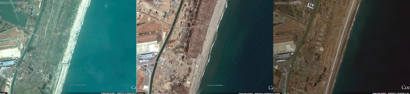
On Google Maps today, you’ll find new aerial imagery for much of Japan’s eastern coastline. This includes the areas of the Tohoku region that were badly damaged by the Great East Japan earthquake and tsunami in March 2011. The imagery shows just how much the landscape of cities such as Soma and Natori have changed in three years. Most of the debris is now gone, and cities have erected tsunami surge barriers. These images tell the story of the progress that is gradually being made to restore Tohoku.
Soma City, Fukushima Prefecture in March 2011, April 2012 and March 2014
Natori City, Miyagi Prefecture in March 2011, April 2012 and March 2014
To view the changing landscapes, zoom in to one of these cities in Google Earth, click “View” and “Historical Imagery”. You can then move back or forward in time by dragging the slider along the timeline.
Posted by Miki Yoshino, Strategic Partner Development Manager, Google Japan


0 comments:
Post a Comment